
New Sidewalk Project: Dayton Avenue N
Survey
Thank you for your participation! The survey is now closed.
Background
When Shoreline incorporated as a city in 1995, it only had approximately 54 miles of sidewalks. We’ve consistently heard from residents since then that availability of sidewalks was a major concern. In the 2022 Resident Satisfaction Survey, only 24% of respondents were satisfied or very satisfied with the availability of sidewalks in their neighborhood.
In 2017 we convened a resident Sidewalk Advisory Committee and worked with the community to develop a method for prioritizing new sidewalks. This work informed the 2018 Sidewalk Prioritization Plan and the 2019 Americans with Disabilities Act (ADA) Transition Plan. Shoreline voters approved a .2% sales tax increase in 2018 to help fund sidewalk construction. We currently have 77 miles of sidewalk and hope to continue to grow that number. (About 75 miles remain to be constructed in order to complete the sidewalk network.)
Located on and near key east-west transit routes, new sidewalks on Dayton Avenue N will provide a safer and more accessible path to bus service serving Shoreline Community College, Link Light Rail, and east to Kenmore. Pedestrians will benefit from safer separation from Dayton’s vehicle traffic. This sidewalk project on Dayton Avenue N is ranked in the plans as high priority and we are excited to get started!
Location
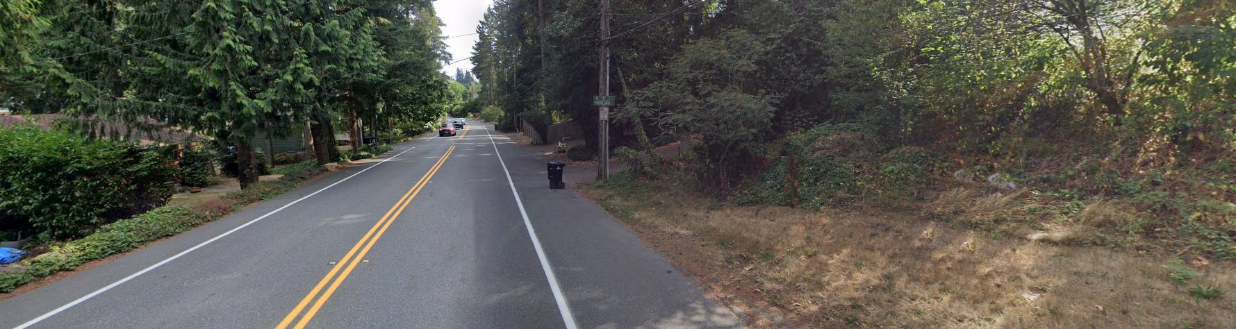
Sidewalk will be constructed on the west side of Dayton Avenue N between N 178th Court and N Richmond Beach Road.

Project need
Currently, the majority of Dayton Avenue N has no sidewalks on either side of the street. There is no physical separation of vehicles from pedestrians and bicyclists on this busy road. In 2022, this section of Dayton saw close to 10,000 vehicles per day.

Project goals
- Provide a safe and more accessible path for pedestrians and bicyclists on Dayton Ave N
- Increase sidewalk & bicycle path connectivity in the City of Shoreline
- Minimize adjacent property impacts, tree impacts, construction impacts
Timeline
This schedule is preliminary and subject to change.
- Preliminary layout - February 2025
- 60% Design - September 2025
- 90% Design - January 2026
- Construction begins - Summer 2026
- Completion - Early 2027
Preliminary Layouts
Our design consultant, DOWL Engineering, studied the project area and developed six options for building this project. Three of the options are on the east side of the street and three on the west. City staff reviewed the options and eliminated the designs on the east side of the street. There is existing sidewalk on the west side of the street south of N 178th Court on Dayton. Connecting pedestrians to that existing sidewalk by keeping them on the same side of the street is the safest option. Constructing on the east side of the street would also impact more private property and remove nearly twice as many trees as the west side alternatives.
The remaining three west side alternatives each have tradeoffs that we need to consider. Cost, an on-street bicycle lane, number of trees impacted, and amenity zones for replanting trees are some of those tradeoffs.
West Alternative 1A
Alternative 1A provides a 6-foot sidewalk, a 6-foot on-street bicycle lane, and amenity zone throughout the length of the project. This alternative has the highest cost, with an estimated price of just over $11M. This alternative also requires the removal of the highest number of trees, with 43 identified for removal.

Includes:
- Amenity zone – 5 feet, full length of project
- Separate bicycle lane – six feet, full length of project
- 6 foot sidewalks
Considerations:
- Highest number of trees removed (43)
- Highest amount of space to replant trees
- Highest cost to build ($11 million)
West Alternative 1B
Alternative 1B is similar to 1A with a 6-foot sidewalk and 6-foot on-street bicycle lane. Amenity zones are provided in some segments of the project area. This alternative has the lowest estimated construction cost of $8.7M. An estimated 36 trees will need to be removed for construction of this alternative.

Includes:
- Amenity zone in some segments of project
- Separate bicycle lane – six feet, full length of project
- 6 foot sidewalks
Considerations:
- Second highest number of trees removed (36)
- More limited amenity zone space to replant trees.
- Lowest cost to build ($8.7 million)
West Alternative 2
Alternative 2 provides a 12- to 14-foot shared use path for both pedestrians and bicycles. There are no amenity zones in this alternative. The cost to build this option is estimated at $9.2M. This option has the lowest number of trees identified for removal - 31.

Includes:
- No amenity zones
- 12’ – 14’ Shared use path (bicycles and pedestrians share space)
- No separate bicycle lane
Considerations:
- Lowest number of trees removed (31), but no amenity zones to replant trees
- Second highest cost to build ($9.2 million)
Alternative Analysis
| Project Elements | West Alternative 1A | West Alternative 1B | West Alternative 2 |
|---|---|---|---|
| Pedestrian Facility | 6' Sidewalk | 6' Sidewalk | 12'14' Shared Use Path |
| Bicycle Facility | 6" On-Street Bike Lane | 6" On-Street Bike lane | |
| Amenity Zone | Amenity zone along all proposed sidewalk | Amenity Zone in some areas | No amenity zone |
| Impact | West Alternative 1A | West Alternative 1B | West Alternative 2 |
|---|---|---|---|
| Total trees to be removed | 43 | 36 | 31 |
| Trees to be removed 24" diameter or greater | 14 | 12 | 14 |
| Potential Right-of-Way Acquisitions Needed | 12 | 8 | 9 |
| Total Properties Impacted (including temporary construction easements) | 16 | 15 | 15 |
| Estimated construction cost | $11.0 million | $8.7 million | $9.2 million |
Tree impacts
This project will require the removal of trees and shrubs. The very early estimates for tree impacts range from 31 to 43 trees for the three design alternatives. We will continue to work to protect trees throughout the design process.
The preliminary Arborist Memo is available to review. Please note that it includes information on tree impacts for three east side design alternatives that are no longer under consideration.